Showing 16 items matching mountain view estate
-
 Kew Historical Society Inc
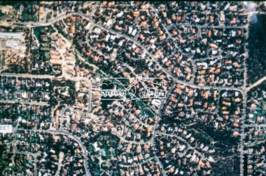
Plan - Subdivision Plan, Camberwell Mountain View Estate, 1923
... Camberwell Mountain View Estate...mountain view estate...The so-called Camberwell Mountain View Estate... Subdivision Plan Plan Camberwell Mountain View Estate The so-called ...The Kew Historical Society collection includes almost 100 subdivision plans pertaining to suburbs of the City of Melbourne. Most of these are of Kew, Kew East or Studley Park, although a smaller number are plans of Camberwell, Deepdene, Balwyn and Hawthorn. It is believed that the majority of the plans were gifted to the Society by persons connected with the real estate firm - J. R. Mathers and McMillan, 136 Cotham Road, Kew. The Plans in the collection are rarely in pristine form, being working plans on which the agent would write notes and record lots sold and the prices of these. The subdivision plans are historically significant examples of the growth of urban Melbourne from the beginning of the 20th Century up until the 1980s. A number of the plans are double-sided and often include a photograph on the reverse. A number of the latter are by noted photographers such as J.E. Barnes.The so-called Camberwell Mountain View Estate was a subdivision on ‘the corner [of] Burke Road, Eyre and Wills Streets, Deepdene’. The Estate was not the first attempt to subdivide this land holding. In 1884, 1888 and 1894 the Belmore Park subdivision proposed 18 allotments for this parcel of land. The final stages of the Belmore Park subdivision occurred during the Depression of the 1890s. Apart from perhaps one block facing Burke Road, which is unnumbered in the Mountain View Estate subdivision, the rest must have remained unsold. The later subdivision would redraw the original 18 allotments, creating 22 new lots. In the Locality Plan on the left side of the subdivision plan, Deepdene Station, which formed part of the Outer Circle Railway is represented, as is the location of Deepdene Primary School. A selling point was the proposed extension of the Burke Road tram beyond its terminus at Cotham Road. The extension did not eventuate.subdivision plans - camberwell, mountain view estate -
 Ringwood and District Historical Society
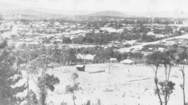
Photograph, A panorama of Ringwood from Mountain View Estate, Loughnan's Hill. (no date)
... A panorama of Ringwood from Mountain View Estate..." and written on back of photograph, "Mountain View estate circular".... from Mountain View Estate, Loughnan's Hill. (no date) Typed ...Typed below photograph, "A Panorama of Ringwood" and written on back of photograph, "Mountain View estate circular". -
 Ringwood and District Historical Society
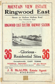
Flyer, Land Sale Brochure, Mountain View Estate, Ringwood East, Vic. - 1923
... Land Sale Brochure, Mountain View Estate, Ringwood East..., Mountain View Estate, Ringwood East, Vic. - 1923 Bi-fold ...Bi-fold advertisement for sale of residential allotments, including photographs, map, and summary of subdivision features and local facilities. Undated handwritten notation reads "streets don't exist today".Subdivision layout includes Mullum Mullum Road, Rangeview Avenue, Press Avenue, and Mountview Avenue. Local Agent - J.B. McAlpin, Opposite Railway Station, Ringwood, Phone Ringwood 7. Vendor - T.J. Press, Builder, "Monterey", Second Avenue, Kew, Telephone Haw. 3428. -
 Ringwood and District Historical Society
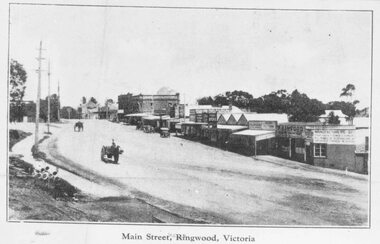
Photograph/Postcard, Main Street, Ringwood, c1924
... , "Coped from a circular for Mountain View Estate, J. Press, vendor..., "Coped from a circular for Mountain View Estate, J. Press, vendor ...Black and white photograph of street scene of roadway with shops and horse-drawn vehicles. (3 enlargements, 1 small photograph and 1 postcard of same photograph with various inscriptions).Typed below photo on postcard "Main Street. Ringwood, Victoria. Valentines Series M.4800" Typed below other small photo, "Main Street, Ringwood, Victoria" Typed on back of this photo, "Coped from a circular for Mountain View Estate, J. Press, vendor, Second Av. Kew. In Mullum Rd, 90 yds from Oban Rd. Press, Rangeview & Mountview Avenues. Winnington just completed. 1924." Typed below one of the enlargements, "Main St. Looking west from Warrandyte Rd. c 1924." Also Black and white photograph - reproduced from postcard. Printed below photograph "....Series No.4. Whitehorse Road, Ringwood." (3 copies) -
 Lorne Historical Society
Map, F W Niven Lithos, The Mountjoy Lorne Estate, 1889
In 1888 a company was formed to acquire and subdivide the land of the Mountjoy Brothers. The land totaled 197 acres and included Erskine House. The land colored red was that of the Mountjoys. The subdivision map was printed in 1889A paper map of the Mountjoy Estate Lorne , showing allotments, with their owners, and naming land use. It has four black and white line drawings , Erskine House, Mountain View’s, the Rapids, Erskine House sea view and Erskine Falls. The map is largely black and white with red and blue colouring. The map is mstuck to brown paper. lorne, subdivision map, erskine house, mountjoy brothers, -
 Ringwood and District Historical Society
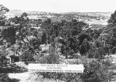
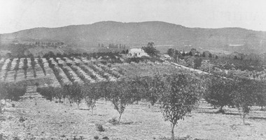
Photograph, Two images of view from Pinemont Estate, Loughnans Hill, looking east, c1930
Black and white photograph of view. Trees and bushes in foreground, orchards and mountains towards background. (2 copies)Typed on photograph, "Pinemont Estate, Ringwood. View Dandenong Ranges, from estate". Typed below photograph, "View from Loughnans Hill, looking east, c1930. Club Hotel can just be seen top right corner". -
 Ringwood and District Historical Society
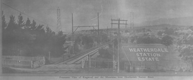
Photograph, View from where Heatherdale railway station is now situated, looking towards Ringwood - 2/2/1924. Land between Heatherdale Rd. and Madden St., sold 2nd Feb. 1924. J.B. McAlpin - agent"
Typed at bottom of photograph, "Panoramic view of Ringwood and the mountains, from Heatherdale Station Estate". Typed below photograph on mounting sheet, "View from where Heatherdale railway station is now looking towards Ringwood - 2/2/1924". "Between Heatherdale Rd. and Madden St., sold 2nd Feb. 1924. J.B. McAlpin - agent". -
 Ringwood and District Historical Society
Photograph, View from Canterbury Road/Balfour Avenue area overlooking Martell's orchard, Heathmont, 1929
Black and white photograph of orchard. House in middle range, mountains in background. Photograph appears to be reproduced from subdivisional brochure. Note inserted in sleeve reads, "It has been pointed out that the mountains are to the east and the view is looking south. This therefore is not a 'straight' photograph. House still exists in Eden Avenue at October, 1996".(3 copies).Typed below photograph, "Panoramic view taken on the estate". "View overlooking Martell's orchard, Heathmont, 1929". Taken from corner Canterbury Rd. and Balfour Ave. looking south. Dandenong Creek just beyond house. Washusen Rd. on right". Written on back of one of the copies, "Heathmont Station Estate 1922". "Station Street, Lisgoold St. Canterbury Rd. Vivienne Cres. Balfour Ave." -
 National Wool Museum
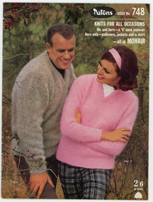
Book, Knitting, Patons Knitting Book no. 748
This book was owned by the late Dr Elizabeth Kerr and was donated to the Museum by the executor of her estate, Margaret Cameron. It was produced by Coats Patons and contains patterns for mens and womens garments knitted in mohair wool. The photographs in this book were taken at 'View Bank', a Welsh mountain pony stud farm owned by Mrs H. Bartramat Heidelberg, Vic.,Patons / BOOK No. 748 / KNITS FOR ALL OCCASIONS / His and hers - a 'V' neck pullover. / Hers only - pullovers, jackets and a skirt / - all in MOHAIR / 2'6 / 25 CENTSknitting handicrafts - history, coats patons (australia) limited, knitting, handicrafts - history -
 Eltham District Historical Society Inc
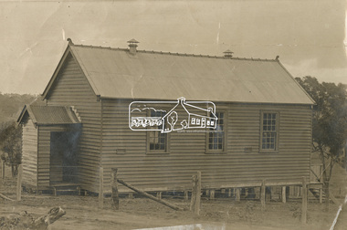
Photograph - Sepia Print, Unidentified hall; possibly the Montmorency Presbyterian Church Hall, Rattray Road, Greensborough, c.1918
From Eltham Montmorency Uniting Church, History http://www.elthammontmorencyuca.org/history/ In 1914 a small group of Presbyterians living on 'The Montmorency Estate', which had been established when the railway was extended to Eltham several years before, began meeting for worship in the Rattray Rd home of Robert Sharpe. Two years later a small weatherboard church, administered from Scots Church, Heidelberg, was built on land donated by Mr. Sharpe. In 1931 this building was moved to the corner of Rattray Road and Mountain View Roads. In the next few years local elders were elected and the congregation adopted the name St. Andrew’s Presbyterian Church, Montmorency.montmorency, montmorency presbyterian church hall, rattray road -
 Eltham District Historical Society Inc
Slide - Photograph, Aerial Photo (c.1987): Woodridge Estate, Eltham, c.Aug. 1990
Part of a presentation, "Roads and Byways of the Shire of Eltham", by Russell Yeoman to the 12 September 1990 Society meeting. Slides shown included copies of old photos and recent images ranging from the suburban streets of Eltham and Montmorency to the mountain roads of Kinglake. In the byways category are views of some iof the Shire's bicycle paths including then recently completed sections of the Main Yarra Trail at Lower Plenty.35mm colour positive transparency (1 of 37) Mount - Agfachrome Agfa CS System black 8 dotsinfrastructure, roads, aerial photographs, eltham, housing estate, woodridge estate -
Whitehorse Historical Society Inc.
Document, Particulars of Land Boom Companies
Research into Land Boom Companies by Keith PattersonResearch into Land Boom Companies by Keith PattersonResearch into Land Boom Companies by Keith Pattersonland subdivision, city investment and finance co ltd, standard property investment co ltd, freehold investment and banking company of australia ltd, commercial finance and property pty ltd, imperial finance and share company, east suburban property investment company, bay and mountain views company limited, east mitcham brick co ltd, imperial banking company, mitcham brick and pottery co ltd, davies, matthew henry, sir, morton, thomas richards burrowes., lachal, gustave, dow, john lamont, stamp, richard, bulmer, fink, theodore, munro & baillieu, mendell, george, fuller, arthur j, taylor, land discount and mortgage bank limited, blackburn township estate co ltd, springfield estate co ltd, royal land co ltd, gascoigne investment co ltd, tunstall brick and pottery company -
 Greensborough Historical Society
Advertising Leaflet, Buckingham & Company: Supporting the Local community, 28/07/2014
"Buckingham & Company: Supporting the Local community, proud sponsors of these organisations". This leaflet lists some of the local organisations sposored by this company. On the reverse, 7 images of homes sold by Buckinghams in 2018: 13 Alban Street Montmorency ($1,850,000), 29 Banfield Terrace Greensborough ($1,061,000), 46 Cressy Street Montmorency ($1,400,000), 46 Mountain View Road ($940,000), 2/8 Wattle Avenue Montmorency ($1,320,000), 2A Rattray Road Montmorency ($670,500) and 3 Crellin Crescent Watsonia ($9000,000).Real estate advertising leaflet, one sheet, printed in colour on one side. 7 small colour images pasted on reverse.buckingham & company real estate agents -
 Greensborough Historical Society
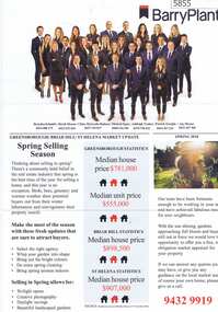
Advertising Leaflet, Barry Plant Bundoora, Barry Plant Spring selling season, 2018_08
Spring selling season leaflet with sales results on back of page. 4 Murumba Street Greensborough, sold $1,115,000 ; 11 Sun Orchid Circuit St Helena sold $870,00; 6 Weemala Court Greensborough sold $1,666,000; 6 Howard Street Greensborough sold $737,000; 136 Elder Street Greensborough sold $772,000; 140 Mountain View Road Briar Hill sold $638,000 and 12 Sunrise Drive Greensborough sold 2018 for $1,320,000, previous sales January 1994 $103,000, July 1989 $100,000 and July 1988 $85,500.Real estate advertising leaflet, 1 sheet, printed in colour on both sides.sunrise drive greensborough, murumba street greensborough, sun orchis circuit st helena, elder street greensborough, howard street greensborough, mountain view road briar hill, weemala court greensborough -
 Greensborough Historical Society
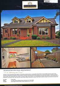
Advertising Leaflet, 1/90 Mountain View Road Montmorency, 11/09/2015
1/90 Mountain View Road Montmorency. 2 bedroom home, private sale, sold 01/03/2013 for $555,000; and i11/09/2015 for $680,000Real estate advertising leaflet, 1 sheet, printed in colour both sidesmountain view road montmorency, mountainview road -
 Ringwood and District Historical Society
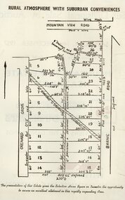
Pamphlet - Land Sales Brochure, Orchard Grove , Heathmont land sales
Land sales pamphlet with hand-drawn 22 allotments of the Estate, Orchard Grove, Heathmont. Also showing Barnic Road and Mountain View Road. Maybe circa 1950s.